These 23 photographs were taken in the 1930s, and show stretches of roads in Bromley Cross, Chapeltown, Bradshaw (Walves), Belmont and Egerton. We think they were probably taken by Turton UDC.
Bromley Cross
 |
| No. 1 - Birtenshaw Corner, Darwen Road, Bromley Cross (20 Aug 1937) |
 |
| No. 2 - Birtenshaw Corner, Darwen Road, Bromley Cross (20 Aug 1937) |
 |
| No. 3 - Darwen Road/Chapeltown Road junction View from railway bridge. The building 'Rose Bank' now demolished. (20 Aug 1937) |
Chapeltown
 |
| No. 4 - High Street, Chapeltown St Anne's Church frontage. (20 Aug 1937) |
 |
| No. 4b - High Street, Chapeltown View south toward Four Lane Ends. Chapel House Farm barn in centre of photograph. (Undated) |
 |
| No. 5 - High Street, Chapeltown View south from St Anne's Church towards Four Lane Ends. (20 Aug 1937) |
 |
| No. 6 - High Street, Chapeltown View north from Four Lane Ends towards St Anne's Church. (20 Aug 1937) |
Bradshaw (Walves)
 |
| No. 7 - Ramsbottom Road, Bradshaw (Walves) View east towards Hawkshaw. (24 Aug 1937) |
 |
| No. 8 - Ramsbottom Road, Bradshaw (Walves) View west towards Bury Rd/Bradshaw Rd junction. Walves Reservoir in centre. (24 Aug 1937) |
 |
| No. 9 - Ramsbottom Road, Bradshaw (Walves) View east towards Hawkshaw. from near Bury Rd/Bradshaw Rd junction. (24 Aug 1937) |
Belmont
 |
| No. 10 - Belmont Road View north towards Scout Road junction. (24 Aug 1937) |
 |
| No. 11 - Belmont Road / Scout Road junction View to south. (24 Aug 1937) |
 |
| No. 12 - Belmont Road, Belmont View north leaving the village. (24 Aug 1937) |
 |
| No. 13 - Belmont Road, Belmont View south entering the village. (24 Aug 1937) |
 |
| No. 14 - Belmont Road, Belmont View south towards the village. Reservoir on the right. (24 Aug 1937) |
 |
| No. 15 - Belmont Road, Belmont View north from near top of reservoir. Buildings now demolished. (24 Aug 1937) |
 |
| No. 16 - Belmont Road, Belmont View north leaving the village. Sailing club on right. (24 Aug 1937) |
 |
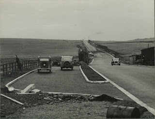
| Belmont Road, Belmont Old Man's Hill View of new lay-bys (Undated) |
 |
| Belmont Road, Belmont Old Man's Hill View of new lay-bys, looking north, with road to Tockholes on the right just below the skyline (Undated) |
Egerton
 |
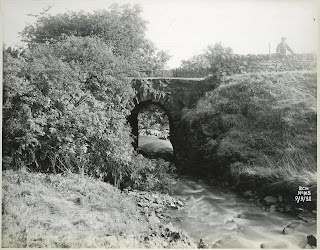
| BWC No. 106 - Stones Bank Road, Egerton Damage to road and bridge where stream from Longworth Moor & Charter's Moss passed beneath stone culvert and fed Delph Reservoir (9 Sept 1932) |
 |
| No. 17 - Stones Bank Road, Egerton Repaired road and bridge five years later (24 Aug 1937) |
 |
| BCW No. 105 - Stones Bank Road, Egerton Damaged photo from north side (see photo BWC No. 106) (9 Sept 1932) |
 |
| No. 18 - Stones Bank Road, Egerton Repaired culvert (5 years later) (24 Aug 1937) |
Viewing tip: To view higher resolution versions of these photographs on your desktop computer, press 'ctrl' while clicking on the image, so that it is opened in a new tab. You can then click on the image in the new tab to zoom in with the magnifying glass.
Our thanks to Keith Barnett, who donated this album several years ago, via Edgworth Horticultural Society.